
GARMIN g2 Vision BlueChart, microSD/SD - VUS036R - USA Binnengewässer
Preis
EUR
224,50*
* inkl. MwSt.
versandkostenfrei (Deutschland)
-2% bei Vorkasse oder Sofortüberweisung
Art.-Nr.: g2v_010-c0737-00
Herst.-Nr.: 010-C0737-00
Lieferzeit:
SPEZIALANFERTIGUNG: ca. 3-7 Werktage!
Beschreibung
Informationen
Frage zum Produkt
1x microSD + SD-Adapter
Abdeckung:
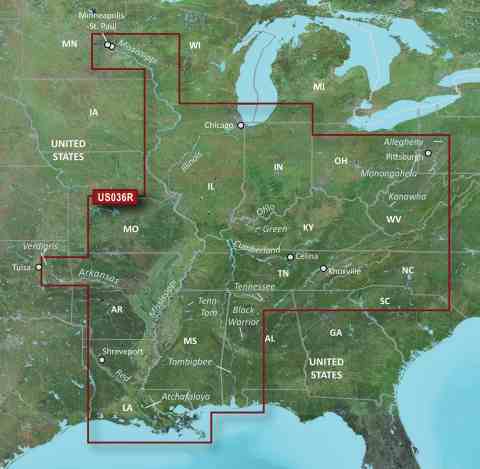
Detailed main channel coverage of the major rivers of the interior of the United States as part of the Great Circle Route. Coverage includes the Ohio, Illinois, Tombigbee, Black Warrior, and Atchafalaya Rivers in their entirety, as well as the Tenn-Tom Waterway in full. Coverage also features the Mississippi River from its junction with the Minnesota River above Minneapolis-St. Paul, MN to the Delta; the Tennessee River from Knoxville, TN to the Ohio; the Cumberland River from Celina, TN to the Ohio; the Allegheny River from East Brady, PA to the Ohio; the Monongahela River from Fairmont, WV to the Ohio; the Kanawha River from Montgomery, WV to the Ohio; the Green River from Rochester, KY to the Ohio; the Verdigris River from the Port of Catoosa to the Arkansas; the Arkansas River from its junction with the Verdigris River outside of Tulsa, OK to the Mississippi; and the Red River from Shreveport, LA to the Mississippi. General coverage of the Gulf of Mexico from Port Arthur, TX to Pensacola, FL; and the southern portion of Lake Michigan from Waukegan, IL to South Haven, MI.
Achtung, bitte beachten Sie:
Bei Bestellung von elektronischen Seekarten ist eine Rückgabe ausgeschlossen.
Diese Seekarten werden von GARMIN ausschließlich für den Kunden angefertigt.
Abdeckung:
Detailed main channel coverage of the major rivers of the interior of the United States as part of the Great Circle Route. Coverage includes the Ohio, Illinois, Tombigbee, Black Warrior, and Atchafalaya Rivers in their entirety, as well as the Tenn-Tom Waterway in full. Coverage also features the Mississippi River from its junction with the Minnesota River above Minneapolis-St. Paul, MN to the Delta; the Tennessee River from Knoxville, TN to the Ohio; the Cumberland River from Celina, TN to the Ohio; the Allegheny River from East Brady, PA to the Ohio; the Monongahela River from Fairmont, WV to the Ohio; the Kanawha River from Montgomery, WV to the Ohio; the Green River from Rochester, KY to the Ohio; the Verdigris River from the Port of Catoosa to the Arkansas; the Arkansas River from its junction with the Verdigris River outside of Tulsa, OK to the Mississippi; and the Red River from Shreveport, LA to the Mississippi. General coverage of the Gulf of Mexico from Port Arthur, TX to Pensacola, FL; and the southern portion of Lake Michigan from Waukegan, IL to South Haven, MI.
Achtung, bitte beachten Sie:
Bei Bestellung von elektronischen Seekarten ist eine Rückgabe ausgeschlossen.
Diese Seekarten werden von GARMIN ausschließlich für den Kunden angefertigt.
Haben Sie eine Frage zu diesem Produkt?